On the way to explore the town of Gerolstein, we stopped in Nohn and did a short hike to the growing Dreimühlen waterfall.
Dreimühlen waterfall
From the parking lot, which is not that big and is immediately occupied when the weather is nice, there is a small circular route of around 2.5 km. The direct path is about 800 m, the paths are well laid out up to the waterfall and are also suitable for prams. The waterfall was created from three source tributaries of the Ahbach, which were brought together because of the construction of a railway line at the beginning of the 20th century. Since the water contains a lot of carbonate, it encrusts the moss-covered stone and thus grows into the valley, approx. 10 cm per year. He has already grown to 12 meters. The stone is completely overgrown with moss and the water is looking for a way down on all sides in small cases.


You can find more information about the beautiful waterfall on the official site.
There is also a small meadow and tables and benches for a little rest. There are various hiking trails around the waterfall, as well as the Eifelsteig again. If you want to have a coffee after the waterfall, you can stop by the Nohner Mühle café on the way back, which even has horse parking spaces.
The city of Gerolstein
Gerolstein is divided by the railway line and the river Kyll. On one side is the center with the pedestrian zone, the old and new town hall, the sports fields and the swimming pool. The other side impresses with the Church of the Redeemer and the Gerolstein Dolomites in the background. Gerolstein is known for its mineral water. The current spring was already used by the Romans and the Celts and the water has been sold since the middle of the 18th century. In some parts of the city you can still find Roman remains, such as an old well in the park, which has, however, been filled up.
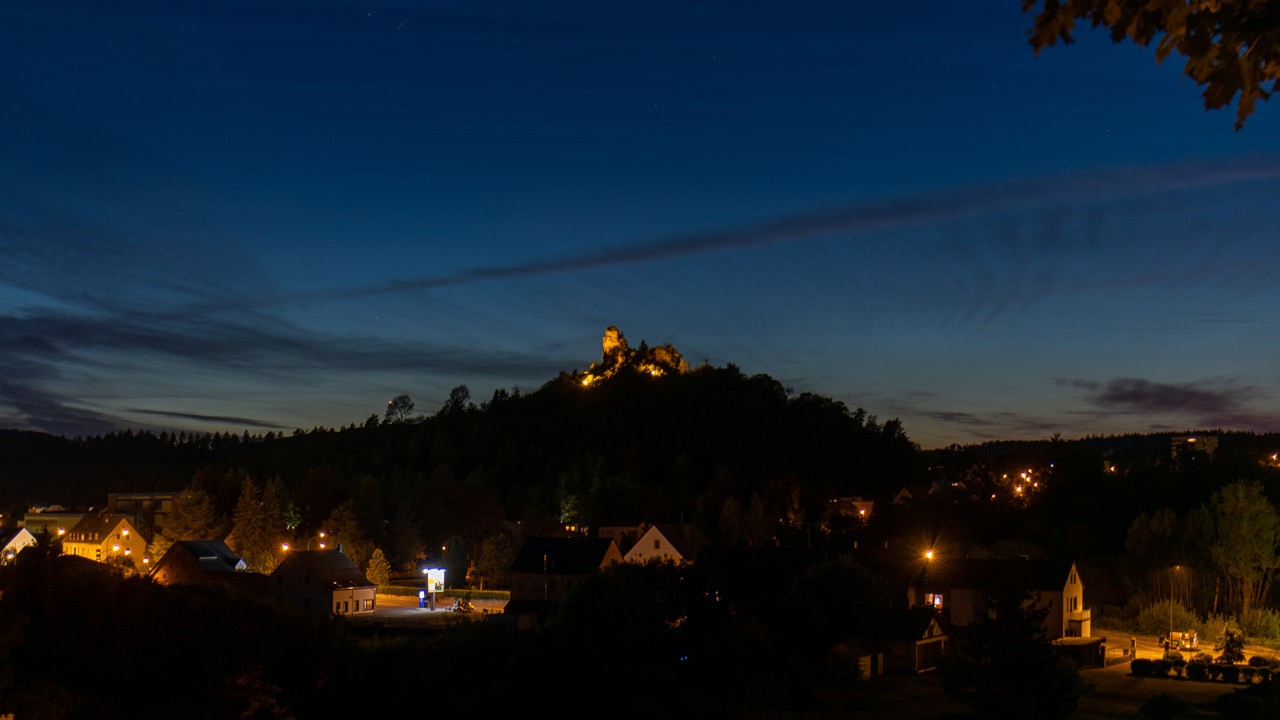
The Protestant Church of the Redeemer was built at the beginning of the 20th century. At the inauguration only 6 years later, Kaiser-Wilhelm II was even present. It belonged to the Hohenzollern family until after World War II. In the background the Munterley, part of the Gerolsteiner Dolomites, is impressive. This is about 100 meters above the valley level and has a viewing platform from which you have a beautiful view of Gerolstein. Millions of years ago, the Gerolsteiner Dolomites were a limestone reef, which was formed by corals and stromatopores.
Well-known pictures of Gerolstein are also the night photos of the illuminated Church of the Redeemer and the illuminated Gerolstein Dolomites. Of course we wanted to have it too. On the first evening we only went there to see it. Then on the 2nd evening with equipment. It just looks great when everything is lit like that! How lucky we were that we started walking around 10 p.m. Sebastian had just finished taking pictures when the lights went out at 11 p.m. Perhaps you should know that if you want to take pictures ... 🙂

The mill stone caves near Hohenfels
On the way to Manderscheid we looked at two small circular routes. The first was a cave tour near Hohenfels Essingen.
These caves are called millstone caves, as the basalt stone was well suited for the production of millstones of any kind in mills. By knocking out the millstones, caves were created, both large and small. The temperature difference is enormous. That day it was 25 ° C and it was really cold in the cave. The small circular route, where you can see 3 such caves, takes about half an hour.
There is also a lookout point along this path that offers a beautiful panoramic view of the country.

Finja had a lot of fun because the circular route is in the forest. She ran into the path and let off steam. When we were on the way back shortly before the parking lot, she stopped and looked at us as if she wanted to say: "That wasn't all." But then she drove on with us ...
Elven grotto with a waterfall
The second small circular route went to the elven grotto (also known as the cheese grotto) with a waterfall. It is only called the Elven Grotto because the 11th mill was located here in the valley. The grotto itself was formed because thousands of years ago a lava flow pushed its way down into the valley. Since it was basalt lava, it formed into columns when it cooled and formed this cave. These pillars look like cheeses stacked on top of each other, hence the name cheese grotto. Next to the grotto, a waterfall finds its way into the valley and flows into the Elbesbach.


