The herd of cows was a special experience. We had seen cows in the wild several times on our hikes. But that they raved about the polar bear was something new for us. We knew that there are areas with free-range cows in Norway, but experiencing it is something different. The polar bear is our home, so we are all the more concerned that something will come of it. I really panicked when they ran past the bus, shoved and fought in front of it. Just don't bump, I thought. It went well again, but I don't need a herd like that again.
Inhaltsverzeichnis
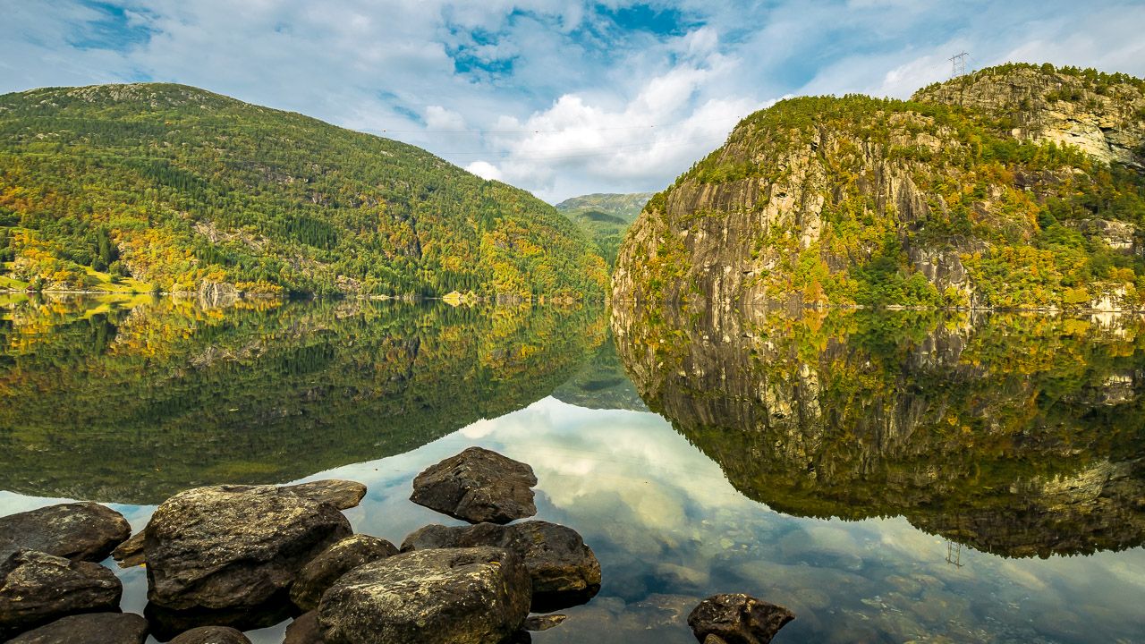
Sognefjellsvegen - Northern Europe's highest pass road
After cooking the soup, we continued down the pass road. The weather was great and we were hoping for a nice view and great pictures. And what can I say, it was just a dream! We stopped often to take pictures and the view was just amazing.

The Sognefjellsvegen has a length of approx. 110 km and the highest point is approx. 1450 above sea level. It used to be a connection between the coast and inland to transport goods. The road is closed during the winter because the snow masses cannot be tackled. It will be open again in May and it is not uncommon for there to be walls of snow 10 meters high.

All around the mountain peaks are covered with a bit of snow and we haven't been that close to a glacier yet. We took a break at a glacier lake and Basti took photos and let the drone fly. At the highest point there was a stone sculpture that looked like a window. The "window" pointed to the glacier.

There was a hiking sign with a circular route. But since it wasn't that early anymore, we didn't walk it. There are also stone towers everywhere that are used as signposts. They show the old trade route and there are signs asking not to build new turrets so that hikers can keep their bearings.

There is another monument on the other side of the street from the “window”. Here larger stones are set up in a circle. The story behind it: every stone stands for a deceased resident. They went on horseback with several people to get food for their village because it was starving. It was winter and everyone froze to death. When you read a story like that, you feel different. Behind it a road went up into the mountains and our app indicated that there were places to stay there. We then walked in a little to take a look around. However, the good places were already taken. But we were able to take snow pictures with Finja.

Then we drove back down the pass, stopping every now and then for pictures. At a lookout point, 2 Swiss people told us that the pass opposite should also be very nice. But a look at the clock and the temperature display for the night kept us from driving the pass. So we're only at that Sognefjord drove down and stood there in a niche right by the fjord. The experience had to be processed first.

https://www.nasjonaleturistveger.no/de/routen/sognefjellet
Gaularfjellsvegen and Likholefossen - pass road and waterfall
We slept pretty well that night. Our plan was actually to drive along the coast and then up to Förde to fill up the gas. Without further ado, we made a different decision, as we discovered another pass road. However, we had to fill up with water beforehand and so we drove to Balestrand. The community has free water there. After we have refueled, we are heading Gaularfjellsvegen hazards.

And again it went up serpentines, just great. This time I was also able to see better when a car came down and therefore stop at the bends or drive slowly. The weather is super sunny again and therefore beautiful views. At the top there was a viewing platform that had different elevation points. Here the wind whistled quite well between the mountains.

The construction of the pass road began in May 1937; the workers were happy to have a job at all, even though it was very hard and dangerous. Her working day was 8.5 hours and ended at noon on Saturday. They only had 2 meal breaks, during which they had no roof over their heads, let alone dry clothes. Her wages were 1 kroner an hour, later then 1.50 kroner. The road was finished in December 1938 and was just a simple gravel road. Very interesting to read something like that.

At first we thought about staying at a campsite because I would have to wash. Since it was already later, we stopped first. In the parking lot of the
Likholefossen you can also stay overnight and so we went there for a walk. There was a bridge over the waterfall that was very narrow and curved very easily. Finja did not dare to walk over there alone. That's how I wore it and on the other side we went down a bit of the watercourse to take pictures. However, you couldn't photograph the entire waterfall and on the other side we saw a small ruin.

Back and down you could photograph the waterfall really well from the big rocks. It was just really nice. The sky was slowly closing, it was cloudy and fresh. We ended the evening, let the impressions of the last few days sink in and then had a good night.
Byrkjelo - campsite for washing
The next day we went to Förde. We exchanged gas bottles there, they actually had German bottles. Basti actually only wanted to have it refilled, but that would have had to have a trained employee on site. We had our plan to drive towards Bergen, overturned again and are heading Jostedalsbreenen National Park driven. at Byrkjelo we then stopped and stood at the campsite for 2 nights.

We have to wash and clean the inside of the car again. When we got there, the washing machine was already in use, but in the evening I was able to wash another machine. There was also a fridge-freezer in the kitchen room. We took advantage of that immediately, as our freezer compartment was completely iced up. So the car was cleaned, the refrigerator was defrosted and the laundry was washed. The dryer was a bit strange, but it worked and so everything worked out that we were going to do.
The campsite was super nice on a lake and the weather played along. It was a bit fresh, but dry and the sun came out in between.

Kjenndals Glacier and Briksdals Glacier - short hike and place to stay
We continued along the Innvikfjorden towards Jostedalsbreenen National Park. We drove in a dead end street direction Kjenndals Glacier. The route along Lovatnet Lake alone was great. At the end of the cul-de-sac there was a large parking lot. Our previous consideration was to stay there overnight. But when we got out and realized how cold it was here, we made a different decision.

But first we walked towards the glacier. It was mostly over stone and was a bit exhausting. Once again no signs, but warning signs about falling rocks, flooding, etc. We are as close as we could to the glacier and it was impressive. There were still waterfalls going down on all sides of the mountains and there was a pretty loud background noise. The river had little water, it was summer.

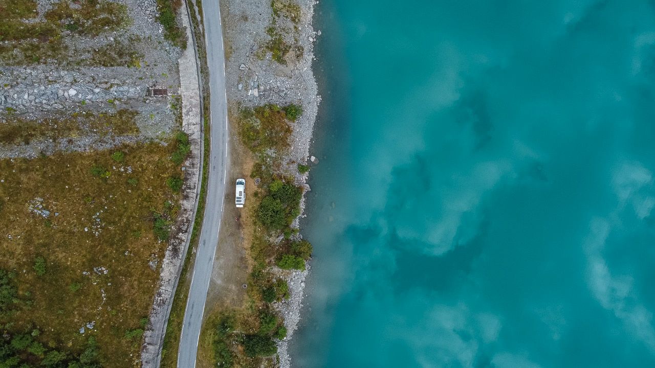
Back at the bus, we checked the thermometer again, maybe to stay. But at 5 p.m. it was just 11 ° C and there was a cold wind. So we drove again and chose another place to stay. So we are then direction Briksdals Glacier driven. There we have on that Oldevatnet Lake stood next to a tunnel. However, this place is not an insider tip, as there were mobile homes on the whole side of the street.

From our place you had a view over the turquoise lake to the glacier. It looked really great. But as beautiful as the turquoise water is, the sadder it is. It is said that the more clearly the color comes out, the more sediments there are in the water. A consequence of the melting of the glaciers. For us, the glacier view was very impressive. But towards evening a German car was parked behind us and Basti was talking to the passenger. She then told him that she had already been here 16 years ago and that she only had tears in her eyes at the current sight of the glacier. This has melted back to a fifth in the 16 years. When you hear that, you feel different.

The next morning we took it easy and drove on late.
You can find more pictures in the Photo gallery Norway.


